Map projections
Map projection is the mapping from the curved surface into a plane.
Introduction
A globe is a spherical model of Earth, of some other celestial body, or of the celestial sphere. Globes serve purposes similar to some flat maps, but unlike maps, do not distort the surface that they portray except to scale it down. A model globe of Earth is called a terrestrial globe. A model globe of the celestial sphere is called a celestial globe.
A globe shows details of its subject. The word globe comes from the Latin word globus, meaning "sphere". A model globe does not distort surface relationships the way flat maps do, but maps can be more useful in many situations.
A globe cannot be transformed to a flat map without distortion, but scores of systems have been devised to display various features and Earth relationships in advantageous ways. Some, like the Mercator, are excellent for a particular purpose but not for most others. A number can be used for general maps, and some for focusing attention on one region, or for making particular measurements, or for various other applications. There are many options.
Explanation
Maps are more compact and easier to store than globes; they readily accommodate an enormous range of scales; they are viewed easily on computer displays; they can be measured to find properties of the region being mapped; they can show larger portions of the Earth's surface at once; and they are cheaper to produce and transport. These useful traits of maps motivate the development of map projections.
A map is a result of mapping of data usually from the real Earth, celestial body or imagined world to a plane representation on a piece of paper or on a digital display such as a computer monitor. Usually, maps are created by transforming data to a spherical or ellipsoidal surface and then to a plane.
To display the whole Earth on a flat map is a complicated operation. Before anything else can be done one must select a map projection to serve as a base. There are many from which to choose in each of the basic classes, and each one can be constructed in any desired aspect (See Map projection classification). One must settle on the necessary properties and parameters and then adopt an appropriate distribution of the inevitable distortion (See Distortion).
Examples

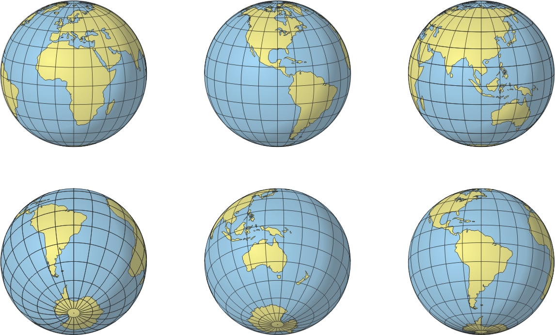
Figure 1: Different aspects of orthographic projection of the Earth. It is one of the oldest and still a favorite. It “looks right” because the increase in distortion toward the edges matches the normal perspective foreshortening that occurs when one observes something spherical. In visual terms, it is a realistic view of a globe.

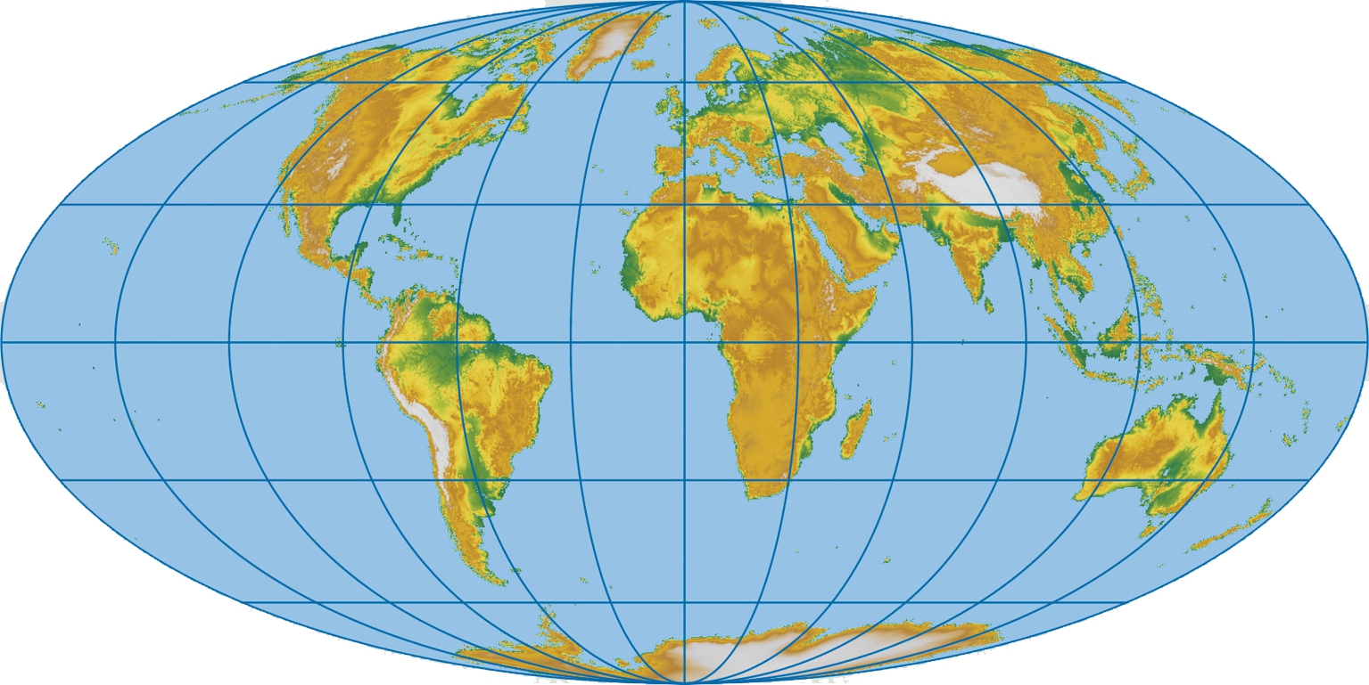
Figure 2: The Mollweide projection. It is equal-area pseudocylindrical projection. Shapes are elongated in the lower latitudes but less crowded in the polar areas.

Figure 3: The logo of the International Cartographic Associtaion (ICA) has the world in Mollweide projection in its central part

Figure 4: Map of the world in normal aspect equal-area azimuthal projection (the projection of the map extends from the North Pole to 60° south latitude) is used for the emblem of the United Nations

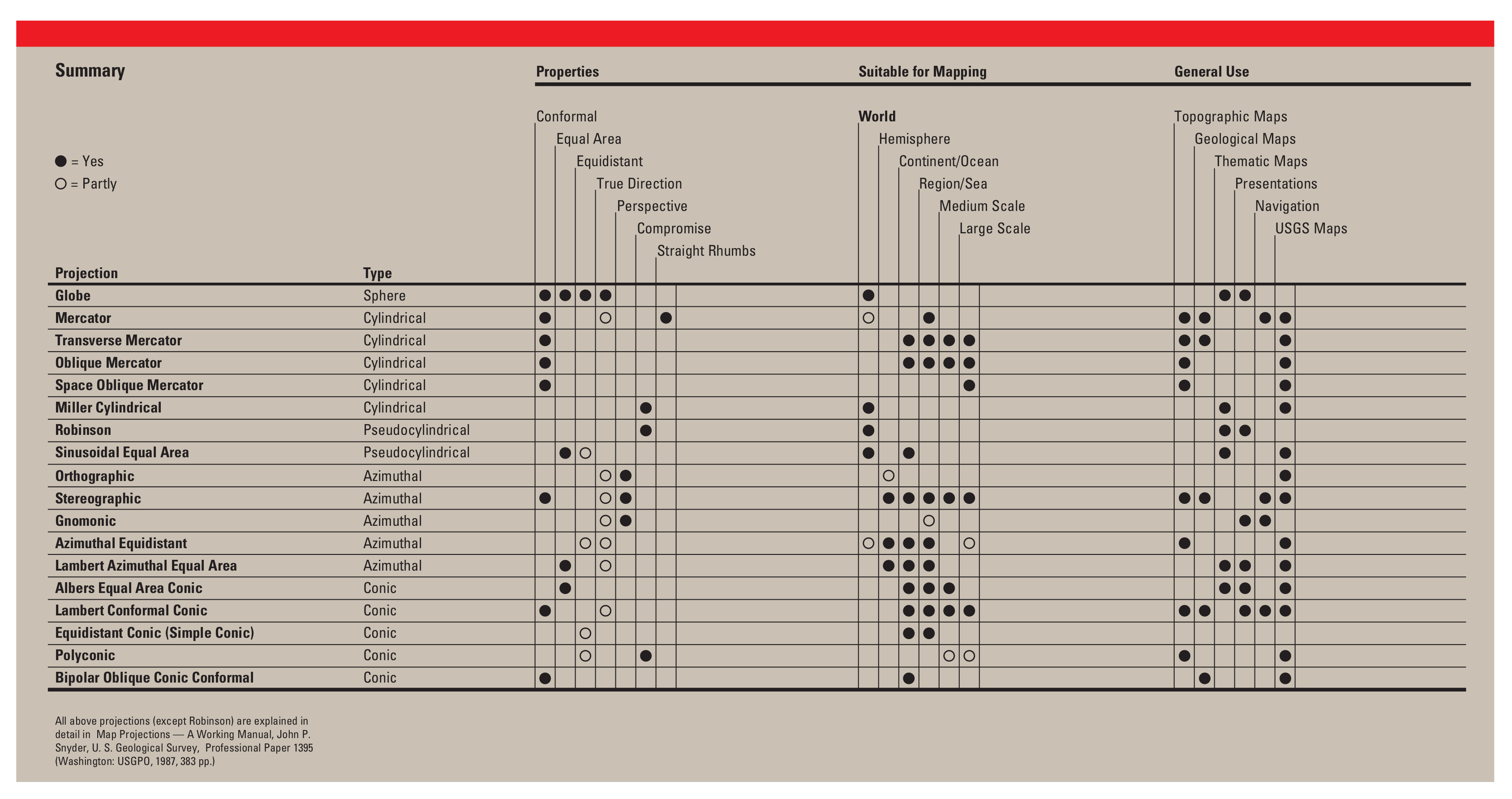
Figure 5: Table of common map projections and their uses reported by USGS
How to
Different projections have different uses. Some projections are used for navigation, while other projections show better representations of the true relative sizes of continents.
For example, the basic Mercator projection yields the only map on which a straight line drawn anywhere within its bounds shows a true direction, but distances and areas on Mercator projection maps are grossly distorted near the map's polar regions. On an equidistant map projection, distances are true only along particular lines, such as those radiating from a single point selected as the center of the projection. Shapes are more or less distorted on every equal-area map.
The scale of a map on any projection is often crucial to the map's usefulness for a given purpose. For example, the extreme distortion that is present at high latitudes on a small-scale Mercator map of the World disappears almost completely on a properly oriented Transverse Mercator map of a small area in the same high latitudes.
The USGS Map Projections poster summarizes and compares eighteen common map projections and their uses (Figure 5).
Synonyms
Cartographic projection
External resources
- Bugayevskiy L M, Snyder J P (1995) Map projections − a reference manual: London, Taylor & Francis
- Lapaine M, Usery E L (2014) Map Projections and Reference Systems, in: F. Ormeling and B. Rystedt (eds.): The World of Maps, International Cartographic Association, Stockholm
- Lapaine M, Usery E L (2017) Choosing a Map Projection, Lecture Notes in Geoinformation and Cartography, Springer
- Lapaine M. (2020) What Are Map Projections and Why Are They So Called? / Što su kartografske projekcije i zašto se tako zovu? Kartografija i geoinformacije, 2020, vol 19, br. 34, 94–103
- Snyder J P (1987) Map Projections − A Working Manual; U.S. Geological Survey Professional Paper 1395; USGS Publications: Washington DC, USA
- Snyder J P, Voxland P M (1989) An album of map projections: U.S. Geological Survey Prof. Paper 1453. Reprinted 1994 with corrections
Learning outcomes
-
1 - Learning outcomes - Map projections
- To be able to define a map projection
- Understand the advantages of a flat map over a globe
- Be aware of the existence of a large number of map projections
- Be aware of the need to know the proper use of map projections
Prior knowledge
Self assessment
Define map projection.
List the advantages of a flat map over a globe.
How many map projections are there?
Why do you need to know the properties of various map projections?
Outgoing relations
- Map projections is subconcept of Map
Incoming relations
- Reference system is subconcept of Map projections
- Map distortion is part of Map projections
- Map projection equations is part of Map projections
- Map projection, classification is part of Map projections
- Term map projection is part of Map projections
Contributors
-
Miljenko Lapaine
Professor emeritus at Faculty of Geodesy, University of Zagreb
https://www.geof.unizg.hr/en/djelatnici/miljenko-lapaine/