Cap STI Values
Explanation
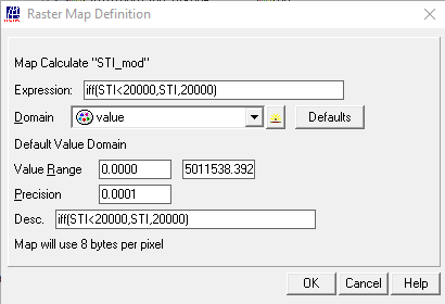
As the stream network has received very high values, the map is going to be slightly modified using the following expression, to set the maximum to an STI value of 20.000:
STI_mod:=iff(STI<20000,STI,20000)
Display the map “STI_mod” and add the color shaded elevation model “colshadow” as a layer under “STI_mod”. For the STI_mod map use a transparency of 45 %, zoom in on the Ethiopian highlands and check the results. Note the remarkable differences between the (steep) valleys and the (flat) plateau’s
as well as the reddish toned stream network. If you also add layer “eth_inland_water”, your results should resemble those provided in the figure below. Note Lake Tana and the Simien Mountains, situated towards the north‐east of the lake
see also : MapCalc
Outgoing relations
- Cap STI Values output Final STI map
Incoming relations
- Sediment Transport Index map input Cap STI Values