Selection based on spatial relationships
Introduction
Various forms of topological relationships between spatial objects were discussed in Topology. These relationships can be useful to select features as well. The steps to be carried out are:
-
select one or more features as the selection objects; and
-
apply a chosen spatial relationship function to determine the selected features that have that relationship with the selection objects.
Explanation
Selecting features that are inside selection objects
This type of query uses the containment relationship between spatial objects. Obviously, polygons can contain polygons, lines or points, and lines can contain lines or points, but no other containment relationships are possible.
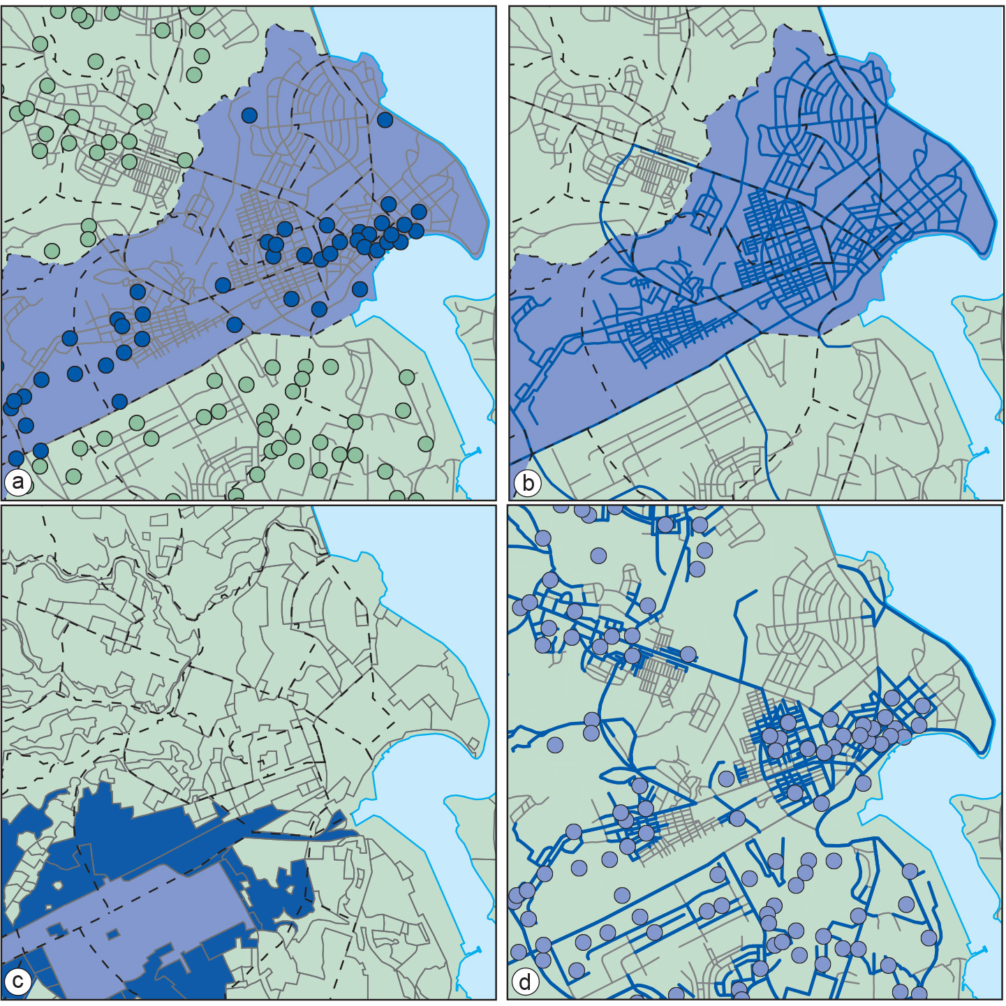
Figure a illustrates a containment query. Here, we are interested in finding the location of medical clinics in Ilala District. We first selected all areas of Ilala District using the technique of selection by attribute condition District = “Ilala”. Then, these selected areas were used as selection objects to determine which medical clinics (as point objects) were within them.
Selecting features that intersect
The intersect operator identifies features that are not disjoint. Figure b provides an example of spatial selection using the intersect relationship between lines and polygons. All roads intersecting Ilala District were selected.
Selecting features that are adjacent to selection objects
Adjacency is the meet relationship described in the subsection Topology. The adjacency operator identifies those features that share boundaries and, therefore, applies only to line and polygon features. Figure c illustrates a spatial adjacency query. We want to select all parcels adjacent to an industrial area. The first step is to select the industrial area (in dark blue) and then apply the adjacency function to select all land use areas (delineated in light blue) that are adjacent to it.
Selecting features based on their distance
One may also want to use the distance function of a GIS as a tool for selecting features. Such selections can be searches for features within a given distance of the selection objects, at a given distance, or even beyond a given distance. There is a whole range of selections of this type. For example:
-
Which medical clinics are within 2 km of a selected school? (Information needed for the school’s emergency procedures.)
-
Which roads are within 200 m of a medical clinic? (These roads must have a high priority for road maintenance.)
Figure d illustrates a spatial selection using distance. In this case, we executed the selection of the second example directly above. Our selection objects were all clinics, and we selected the roads that pass within 200 m of a clinic. For situations in which we know the distance criteria to use—for selections within, at or beyond that distance value—the GIS has many (straightforward) computations to perform. Things become more complicated if the distance selection condition involves the word “nearest” or “farthest”. The reason is that not only must the GIS compute distances from a selection object A to all potentially selectable features F , but also that it must find the feature F that is nearest to (or farthest away from) object A. So, this requires an extra computational step to determine minimum (maximum) values. Most GIS packages support this type of selection, though the mechanics (“the buttons to use”) differ among packages.
Learning outcomes
-
11 - Spatial analysis: classes of functions
Classify and explain spatial analysis functions (measurements, classification, overlay, neighbourhood and connectivity) in a raster and vector environment (level 1 and 2).
Prior knowledge
Outgoing relations
- Selection based on spatial relationships is a kind of Query
Incoming relations
- Topological relationship is used by Selection based on spatial relationships