Calculate Sediment Transport Index
the sediment transport index accounts for the effect of topography on erosion. The two-dimensional catchment area is used instead of the one-dimensional slope length factor as in the Universal Soil Loss Equation
Explanation
The equation for the index applied is derived from Burrough and McDonnell (1998):
STI=(As / 22.13)0.6 × sin(
Where: As is the unit contributing area (in m2/m)and β is the slope angle (in degrees) at a given pixel.
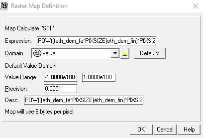
Type the following expression on the command line in the main ILWIS menu and press to execute the calculation:
STI:=POW(((eth_dem_fa*PIXSIZE(eth_dem_fin)*PIXSIZE(eth_dem_fin))/(22.13)),0.6) * POW(SIN(DEGRAD(slopedeg))/0.0896, 1.3)
See also : MapCalc
Outgoing relations
- Calculate Sediment Transport Index output Sediment Transport Index map
Incoming relations
- DEM input Calculate Sediment Transport Index
- Flow Accumulation map input Calculate Sediment Transport Index
- Slope map (degrees) input Calculate Sediment Transport Index