19 - SDI Environment
Describe and apply the basic processes, processing, analysis and conversion in an SDI environment while combining multiple data sets from various remote sensing and other sources and explain challenges in data integration. Describe and use various methods of change detection. (Max. level 3)
Concepts
-
Spatial Data Infrastructure (SDI)
In [1] an SDI is defined as the relevant base collection of technologies, policies and institutional arrangements that facilitate the availability of and access to spatial data. Several definitions of an SDI exist, however, each adjusted slightly to fit specific needs (see [1]).
[1] D. Nebert, editor. Developing Spatial Data Infrastructures: The SDI Cookbook. The Global Spatial Data Infrastructure Association (GSDI), version 2.0 edition, 2004. http://www.gsdi.org/docs2004/Cookbook/cookbookV2.0. -
SDI nodes
From an architectural point of view, an SDI is a collaborative network of disparate systems called SDI nodes. An SDI node is a moderately to highly complex information system, usually of long life expectancy, in which geo-resources feature rather prominently. SDI nodes are totally independent systems, which means that t they also have to fulfill requirements that are different from those of the SDI itself.
-
Geo-webservice
Modern SDIs are based on webservices, which are defined as mechanisms designed to support interoperable machine-to-machine interaction over the Web.
-
Web 2.0
Web 2.0 refers to what is perceived as a second generation of Web application development and Web design. Web 2.0 does not refer to any specific change in the technology of the Web, but rather the way in which developers implement websites and thus to the way in which people perceive and use the Web. Web 2.0 applications are characterized by their interactivity and user-centred design.
-
Web Portal
Once services have been implemented for different SDI nodes, a common practice is to facilitate their access by building portals. Spatial web portals can be thought of as a gateway that provides access to geo-resources via geo-webservices on the Web. A web portal is simply a website that gives visitors organized access in a unified way, typically through catalog services, to geo-resources on the Web, and preferably also to the people and organizations offering those geo-resources (see Figure 1). A portal potentially offers access to many other sites. Consequently, a web portal can also be used to aggregate content.
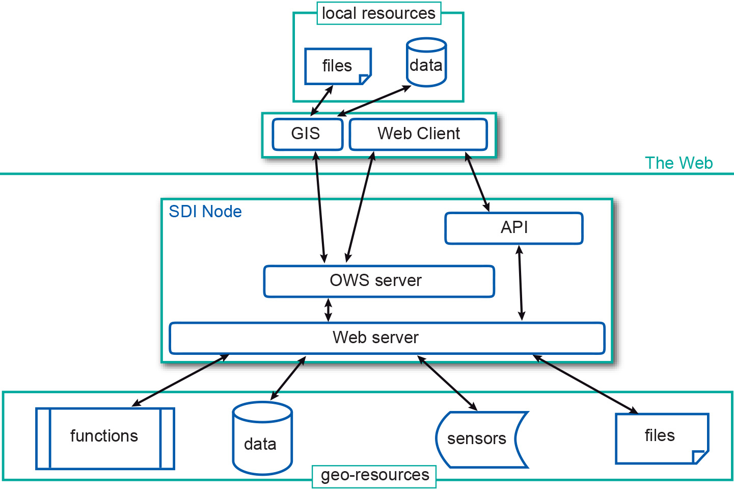
Figure 1: SDI node architecture and communication patterns