Compute slope in percentage
Combining the x derivative and y derivative to create a slope map
Introduction
Having obtained the elevation differences in X and Y direction the slope can be derived as the
pixel size is constant in both X and Y direction.
Explanation
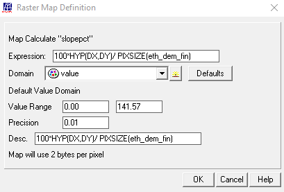
The slope in percentage is derived using the following command, which can be typed on the command line within the main ILWIS menu:
slopepct:=100*HYP(DX,DY)/ PIXSIZE(eth_dem_fin)
press “OK” to start the computation. Display the map “slopepct” and check the values.
Outgoing relations
- Compute slope in percentage output Slope map (%)
Incoming relations
- Elevation Differences maps input Compute slope in percentage