Slice
slopedeg_cl
Introduction
Explanation
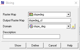
In order to slice the slope map, from the main ILWIS menu, select the
option “Operations” > “Image Processing” > “Slicing”, as Raster map select “slopedeg”, as domain “slope_deg” and as output raster map specify “slopedeg_cl” and press “Show”.
see also : Slicing
Outgoing relations
- Slice output Classified Slope Map (degrees)
Incoming relations
- Slope map (degrees) input Slice