Multi concept
Introduction
Remotely sensed data are often multispectral, sometimes multi-angular, and in some cases also multi-temporal, for instance when time series of satellite data are analysed to discover changes in surface properties or to monitor processes on Earth. If the spectral, angular and temporal domains are exploited to retrieve information about the surface, the data analysis and processing operations become more complicated, but one can retrieve more information from the data. This is why data integration is useful.
Explanation
Remotely sensed data are often multispectral, sometimes multi-angular, and in some cases also multi-temporal, for instance when time series of satellite data are analysed to discover changes in surface properties or to monitor processes on Earth. If the spectral, angular and temporal domains are exploited to retrieve information about the surface, the data analysis and processing operations become more complicated, but one can retrieve more information from the data. This is why data integration is useful.
A few examples of multiple data observations are:
- colour photography
- multispectral remote sensing
- hyperspectral imaging
- multi-temporal image analysis
- multi-frequency and dual polarization SAR (synthetic aperture radar)
- multi-angular optical observations
- day–night thermal images.
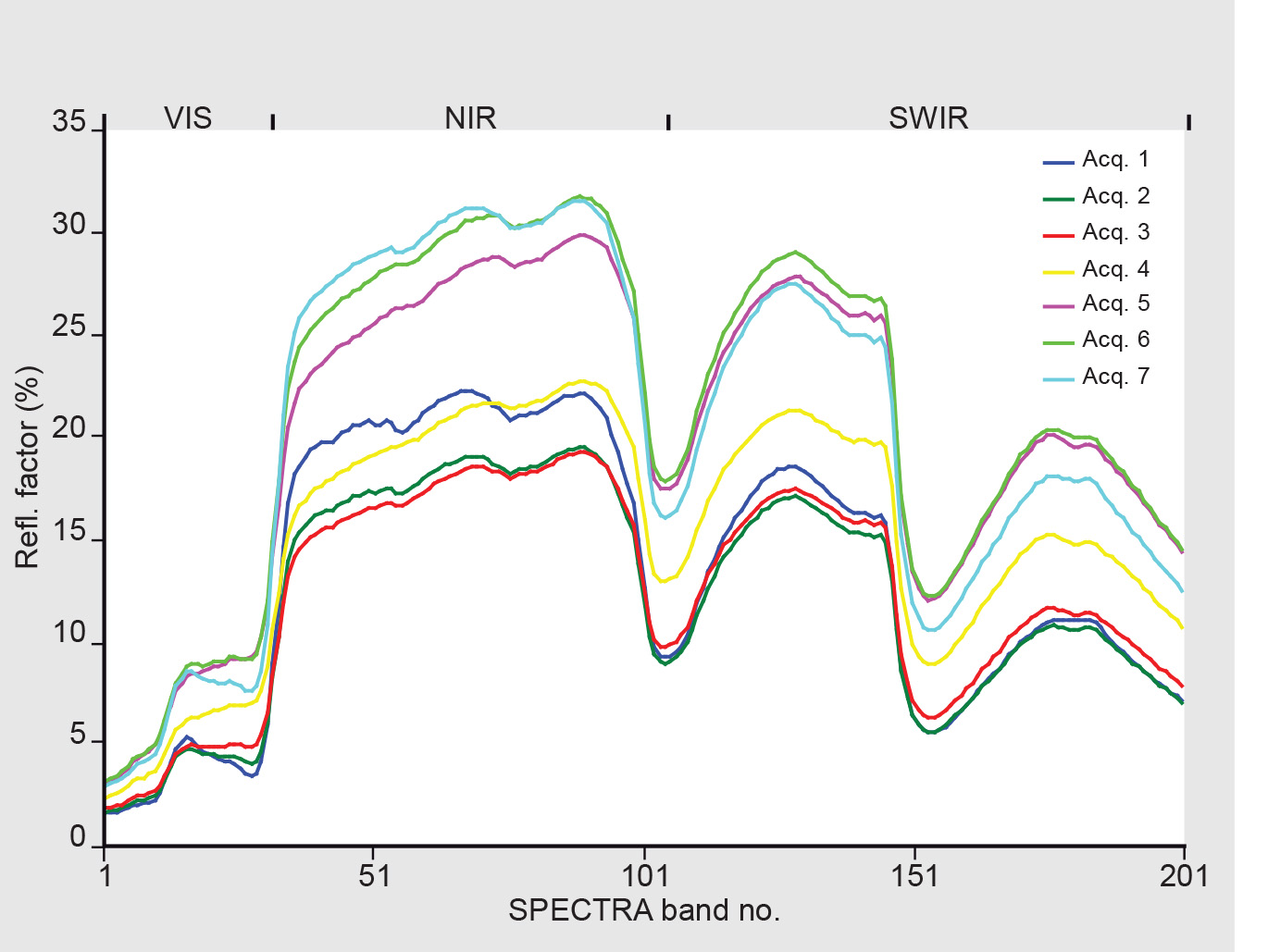
An example of simulated multi-angular observations with a hyperspectral sensor is given in Figure 1, which shows how for a sparse vegetation object the observed reflectance spectrum in 201 bands changes with the image acquisitions from space under 7 different directions.

different directions (model
simulation)
Remote sensing data can not only be combined with other remote sensing data, but also with existing geospatial information, for instance the geographic information stored in a GIS.
Some examples are:
- digital elevation models (DEMs)
- land use information (GIS data)
- field measurements
- predictions from process models.
Examples
The multi concept is often applied in remote sensing because multiple observations provide more information, in the sense that objects which look similar in a certain set of observables (spectral bands, times, angles) may look different if the number of observables is increased. Avery simple example is the difference between a black&white and a colour photograph. Objects which look similar in black & white photograph the multi concept may have totally different colours, so they become better distinguishable in a colour photograph. Another example, based on using multi-temporal data, can be found in objects that show similar behaviour as a function of time up until summer, but then start behaving differently. The difference will only become obvious if observations from both “before” and “after” are available.
Outgoing relations
- Multi concept is related to Data integration
Incoming relations
- Combining data from multiple sources is based on Multi concept