Positioning system
Introduction
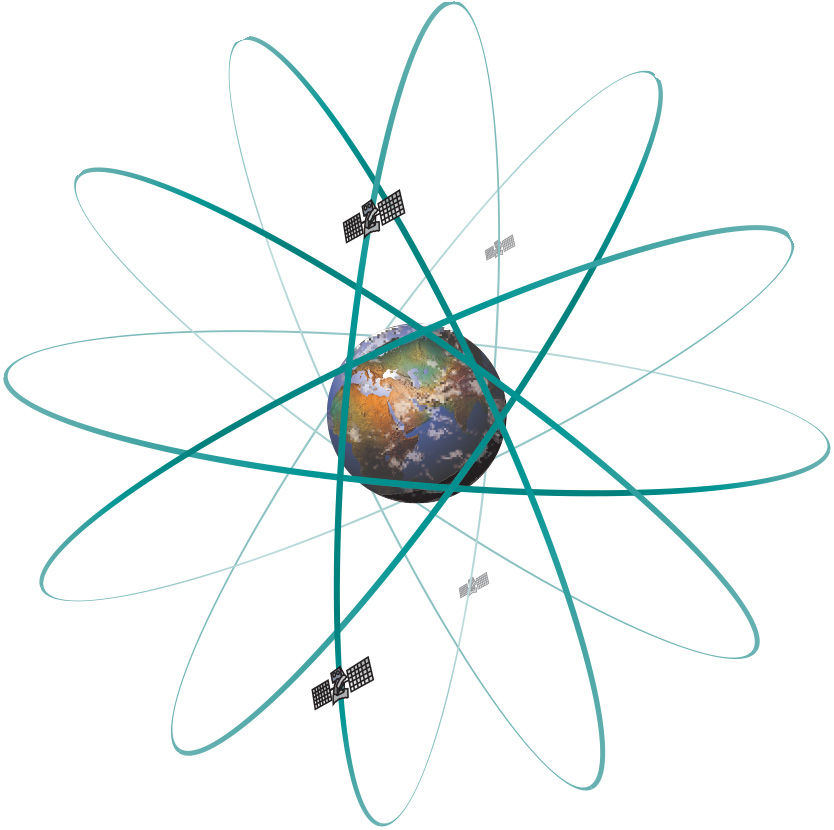
At present, two satellite-based positioning systems are operational - GPS and GLONASS - and a third is in the implementation phase - Galileo. These systems are US, Russian and European, respectively. Any of them, but especially GPS and Galileo, will be improved over time and will be augmented with new techniques.
Explanation
GPS
The NAVSTAR Global Positioning System (GPS) was declared operational in 1994, providing Precise Positioning Services (PPS) to US and allied military forces, as well as US government agencies; civilians throughout the world have access to Standard Positioning Services (SPS). The GPS space segment nominally consists of 24 satellites, each of which orbits our planet in 11 h 58 min at an altitude of 20,200 km. There can be any number of satellites active, typically between 21 and 27. The satellites are organized in six orbital planes, somewhat irregularly spaced, at an angle of inclination of 55–63∘ to the equatorial plane; nominally four satellites orbit in each plane. This means that a receiver on Earth will have between five and eight (rarely, even up to 12) satellites in view at any moment in time. Software packages exist to help in planning GPS surveys, identifying the expected satellite set-up for any location and time.
The NAVSTAR satellites transmit two radio signals, an L1 frequency of 1575.42 MHz and an L2 frequency of 1227.60 MHz. There is also a third and fourth signal, but these are not important for the discussion here. The role of the L2 signal is to provide a second radio signal, thereby providing a way, with (more expensive) dual-frequency receivers, of determining fairly precisely the actual ionospheric delay of the satellite signals received. GPS uses WGS84 as its reference system, which has been refined on several occasions and is now aligned with the ITRF at the level of a few centimetres worldwide. GPS has adopted UTC as its time system. For civilian applications, GPS receivers of varying quality are available, their quality depending on the embedded positioning features: supporting single- or dual-frequencies; supporting only absolute or also relative positioning; performing code measurements or also carrier phase measurements.
GLONASS
What GPS is to the US military, is GLONASS to the Russian military, specifically the Russian Space Forces. Both systems were primarily designed on the basis of military requirements, but GLONASS did not significantly develop civil applications as GPS did and thus it is commercially less important. GLONASS’s space segment consists nominally of 24 satellites, organized in three orbital planes, at an inclination of 64.8∘ to the Equator. Its orbiting altitude is 19,130 km, with a period of revolution of 11 h 16 min. GLONASS uses the PZ-90 as its reference system and, like GPS, uses UTC as its time reference, albeit with an offset for Russian daylight. GLONASS’s radio signals are somewhat similar to those of GPS, differing only in the details: the frequency of GLONASS’s L1 signal is approximately 1605 MHz (changes are underway), and its L2 signal approximately 1248 MHz; otherwise, GLONASS’s system performance is rather comparable with that of GPS.
Galileo
In the 1990s, the European Union (EU) judged that it needed its own satellite-based positioning system, to become independent of the GPS monopoly and to support its own economic growth by providing services of high reliability under civilian control.The EU system is named Galileo. The vision is that satellite-based positioning will become even bigger due to the emergence of mobile phones equipped with receivers, perhaps with some 400 million users by the year 2015. The development of the system has experienced substantial delays; currently European ministers insist that Galileo should be up and running by the end of 2013. When completed, Galileo will have 27 satellites, with three in reserve, orbiting in one of three, equally spaced, circular orbits at an elevation of 23,222 km and inclined at 56∘ to the Equator. This higher inclination (when compared to that of GPS) has been chosen to provide better positioning coverage at high latitudes, such as in northern Scandinavia, where GPS performs rather poorly. In June 2004, the EU and the US agreed to make Galileo and GPS compatible by adopting interchangeable set-ups for their satellite signals. The effect of this agreement is that a Galileo/GPS tandem satellite system will have so many satellites in the sky (close to 60) that a receiver can almost always find an optimal constellation in view. This will be especially useful in situations where in the past signal reception was poor, in built-up areas and forests, for instance. It will also bring the implementation of a Global Navigation Satellite System (GNSS) closer, since positional accuracy and reliability will improve. Such a system would bring the ultimate development of fully automated air and road traffic control systems much closer. Automatic aircraft landing, for instance, requires a horizontal accuracy in the order of 4 m, and a vertical accuracy of less than 1 m. Currently, these requirements cannot be reliably met. The Galileo Terrestrial Reference Frame (GTRF) will be a realization of the ITRS and will be set up independently from that of GPS so that one system can back up the other. Positional differences between WGS84 and GTRF will be at worst only a few centimetres. The Galileo System Time (GST) will closely follow International Atomic Time (TAI), with a time offset of less than 50 ns for 95% of the time over any period of the year. Information on the actual offset between GST and TAI, and between GST and UTC (as used in GPS), will be broadcast in the Galileo satellite signal.
Prior knowledge
Incoming relations
- Satellite-based positioning is based on Positioning system